
Yes you heard me right and no your eyes are not deceiving you. You can now upload videos on flickr! Only short clips of 90 seconds are allowable and limited to Pro users (paying customers). Nonetheless, I feel less pressure putting short unedited clips on flickr than on youtube. So here's a good way to start my collection of videos on flickr! I've uploaded a video of Tanjong Rimau, Sentosa during the first NHC recce at Sentosa a year ago! It was also before the beacon got broken into two. A future classic in the making?
During tomorrow's guest lecture, I will try to use all my new toys and web services. Recording my talk with my new digital voice recorder, podcasting it and uploading some videos on flickr video! Not forgetting putting up my slides on slideshare! Maybe I can now make a slidecast
Update @ 1.34pm 9 Apr
For the buffaloes out there, here is what you are looking at.
View Larger Map
I could not resist using more webapps but here's google map showing an aerial view of the surrounding places that may have been spotted on the video. The placemarker (the blue tear drop) indicates where the video was taken. You can see labrador park and the port beyond. The green beacon you see is situated at the tip of Sentosa, which is also known as Tanjung Rimau. Tanjung is malay for the coastal feature of a "cape", defined as a "strip of land projecting into a body of water". To further orientate yourself around the map, Sentosa is the piece of green at the bottom of the map. 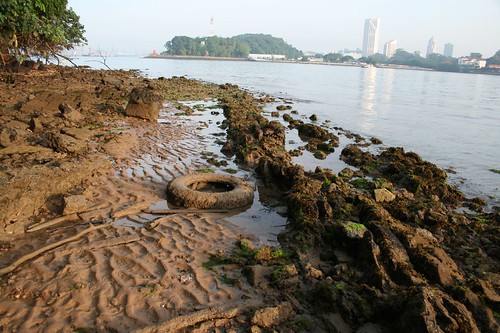
This photo is taken a few meters down from where the video was taken. Ignore the marine trash but you can see some of the coastal platform near the bottom left of the picture
Tanjung Rimau is a wonderful rocky shore and cliff habitat, totally natural and one of the last remaining ones. Of course, looking at labrador, there you have actually the last mainland cliff in Singapore. It would look similar to what you see here. What I'm standing on is actually a coastal platform which means the waves has cut it flat very beautifully. The grooves just means that some minerals within the rock is more soluble than others and thus formed the feature which you see here.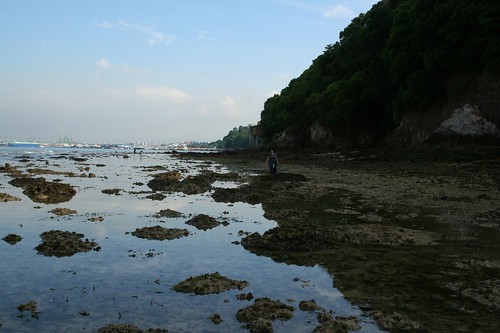
This photo is taken on the other side of the cape (tanjung), facing Indonesia and the rest of the southern islands. The video was taken on the side of the cape facing Singapore [refer to placemarker]. Yes this is Sentosa, hard to believe isn't it?
For more photos of the area, see my flickr photos.
Wednesday, April 09, 2008
Video of Tanjong Rimau, Sentosa on Flickr
![]()
 I can be contacted at


1 comment:
Monkey Monkey! Try describing the place in your video so buffalos like me can understand what we're looking at. ;)
Post a Comment