Showing posts with label hazards. Show all posts

Thursday, August 06, 2009

Haze is back


This morning I took this picture from my office building. Seems like the haze is back indeed. Although I saw the haze at home this morning, a visit to NEA website this morning stated PSI was still good. I wonder if it got worse in the next update. Oh well. This Channel NewsAsia article shows that it did.

Haze in Singapore as 50 hot spots detected in Sumatra
By Hasnita A Majid, Channel NewsAsia
06 August 2009

SINGAPORE: The haze is back in Singapore and you can expect more hazy days ahead.

Smoke haze shrouded Singapore on Thursday morning, with an acrid burning smell hanging in the air.

And the Pollutant Standards Index (PSI), which measures the air quality in Singapore, was around 60 on Thursday.

Though this is still in the moderate range, it is however slightly higher than Wednesday's reading of 52.

Smoke haze has been blowing into Singapore and the National Environment Agency (NEA) said that over the past few days, its satellite pictures detected significant hot spots with moderate to dense smoke.

The hot spots are mainly in the Sumatran provinces of Riau, Jambi and South Sumatra.

On Thursday alone, 50 hot spots were detected in Sumatra.

NEA added that with prevailing dry weather in the region and the wind direction expected to remain the same in the next few days, hazy conditions can be expected in Singapore over the next few days.

Doctors have cautioned against outdoor activities if the situation worsens, especially for those with respiratory illnesses.

Dr Chuah Li Li, a general practitioner from My Family Doctor, said: "Usually the discomfort is felt in the eyes, where people will feel there is a little bit of the smarting discomfort or a dry sensation. The other thing that you might feel is the throat discomfort.

"For people who have lung problems, chronic obstructive lung disease and asthma, there might be a sensation if there's a little bit of difficulty in breathing and a chest tightness or cough.

"Elderly people with pre-existing lung condition or children with asthma should actually cut down on outdoor activities, especially strenuous activities like playing basketball and football."

But members of the public are not too concerned about the situation now.

"At the moment, still not so serious, maybe if it gets serious, we will do some precautionary measures," said a member of the public.

Singapore has expected the haze to return this year as the El Nino weather phenomenon develops, bringing with it hotter and drier weather.

The situation is expected to worsen in the coming months, especially when the dry weather peaks in September.

The haze is the result of smoke from slash and burn activities in Indonesia, when farmers clear their lands to make way for new crops.

Hot and dry weather can also cause dry twigs and leaves to burst into flames spontaneously.

Just recently, Singapore handed over three air and weather monitoring stations to Jambi Province in Sumatra to help calculate the risk of fires starting and spreading in the surrounding areas during dry weather.


Read full article here

Friday, October 26, 2007

Use Twitter in Crises


As previously during the earthquake in Sumatra leading to tremors in Singapore, Twitter has again come of use during yet another times of crises. This time, not just by users but by emergency services.

KPBS is the local San Diego news station and they have taken on to Twitter as well during this time of fire crises in the San Diego county. Notices of road closures yesterday and today, messages to evacuated residents to return home!


Even at night it keeps burning. I can't imagine how it's like there right now, full of ash and dust. Worse than our haze. Source: sarah.c

For me in Singapore, it is the only way to get in touch with the news in San Diego where my fiance and his family lives! Most of the news in Singapore focus on the south Los Angeles county mega-homes while the lives of displaced farm workers in San Diego goes unnoticed.

I could of course sit in front of the computer all day and try to look out for depressing news as they get updated regularly. Alternatively, I could go about my work and get messages sent to my phone via Twitter. Otherwise I just check on twitter every so often together with the rest of my twitter messages online.


W's family lives near the area being evacuated. Source: Eric Byers

This is a perfect case study of how twitter can be of use in a productive and efficient manner. Twitter updates can be sent directly to subscribers' cellphones and even if power is out, you have no Internet access at home, you can still get these messages on your phone. Of course, for those with relatives in San Diego but unable to find out news on their local television network, this is also perfect. There was power outage in the beginning of the fire and I know that some of the local news websites were down. Also, twitter allows for short messages which may not fit into the scheme of things in an actual news website.


The sky over Chula Visa. I'm visiting in 2 months. I wonder if the air quality is going to be just as bad. Source: rennae_lc

Of course radio is still the preferred tool of communications in event of crises but not everybody hangs on to the radio. Twitter now proves to be the new alternative in emergency communications. It also shows how mainstream media is now integrating with web 2.0 technology for more effective communication. After all you stop drawing the line between mainstream and web media when a crisis is at hand!


Read full article here

Wednesday, September 12, 2007

Earthquake in Indonesia, Tremors in Singapore

Update on September 13:
It appears the earthquakes and tremors are yet to be over. Latest updates at the bottom of the post.


This is truly a classic case of the beauty of web 2.0 connectivity.

14 minutes ago at around 7.29pm, Otterman posted a vague message on twitter.com:

"So it was tremors, not a giddy spell. Adrian [lekowala] says neighbourhood getting out of flats in Sengkang... he's at ground floor now"


Photo by Lekowala in Sengkang

At 7.35pm, I reread the message and decided to investigate if there was an earthquake and by searching for "tremors singapore" on Google, the 2nd hit was NEA's website on "Latest Regional Earthquakes" which kindly provided me with the information I was looking for.

30 minutes ago at around 7.10pm, a earthquake of magnitude 7.15 on the Richter Scale was measured off the Southwest of Sumatra. The website reports that a "local tsunami may be generated near earthquake source but unlikely to affect Singapore". This really proves that NEA is on top of their updates. I am rather glad of their efficiency.


Location of earthquake at Sumatra in red square. Map from USGS.

However, it must have been rather serious for it to be felt all the way in Sengkang, Singapore. However, while I was happily sitting here in my office in NUS, I felt nothing and am still awaiting confirmation from Otterman if he felt the tremors or was it only Lekowala.

A class in Natural Hazard 2 years ago taught this monkey that our friends in the Eastern Singapore is more likely to feel tremors as the ground they are on are made of sedimentary alluvium material which is less stable than the granite and what not other hardier material that we are seated on.

Unbelieving that nobody else has picked up on this, at 7.44pm, I made a search on Google News and no news agency has picked up this earthquake yet. At 7.49pm, I again searched for news and see that Channelnewsasia has made a "breaking news" entry on their front page stating that a 7.9 earthquake has struck Indonesia. As usual, there are magnitude discrepancy during the first hour of the earthquake hitting. Google has also picked up a one line feed from Associated Press stating that a powerful earthquake has made Jakarta buildings sway. Apparently at 7.41pm, CNA has made a report of Singaporeans feeling tremors but did not mention any details of location, instead providing only background to the earthquake and past events.

I'm still waiting for images to come in and for Lekowala to show some photos or perhaps to blog about the tremors in Singapore!

Updates
7.58pm: Otterman said that he felt tremors not in NUS but at Holland Village. I stick to my original argument that Kent Ridge is on hardier ground, geologically. USGS reports the earthquake to be 7.8 but NEA has yet to make any changes. Subscribe to USGS's earthquake RSS feed from around the world to keep updated on the latest.


Photo uploaded by 9.

8.06pm: Found that at 7.35pm, a friend uploaded the earthquake location map (above) on flickr as well as the breaking news headline on CNN (below). The easy to use photo sharing mechanisms at work! Naturally he also blogged about it. Apparently at 7.14 Singapore time, all hell broke lose on the Hardwarezone Eat Drink Man Woman forum. Cowboybar is no slower with members posting about the tremors at around 7.20pm when a member felt the quake downtown. 5 minutes later, other members reported tremors from Bukit Panjang.


Photo uploaded by 9.

This sharing of information in real time, at different places in Singapore, sharing experiences and checking on friends is absolutely effective. Meanwhile, I am getting in touch with people on instant messaging programs. On the other hand, said friend is waiting for youtube videos of buildings shaking. Is that too optimistic? Depends on how badly it shook I suppose. This is indeed the age of information sharing and high speed connectivity.


Screenshot of Hardwarezone forum reporting on tremors. By Kingmeng

8.06pm: Otterman blogged about the tremors and updating me on MSN. He also blogged about the tremors from the March 2007 earthquake where he likewise did not feel anything on the Ridge. Nonetheless the SCDF Civil Defence handbook gives detailed guidelines on what to do in the event of an earthquake or aftershock tremors.


Taken from SCDF Website.

So far locations where tremors have been reported:

NORTH-NORTHEAST
1) Sengkang
2) Woodlands
3) Serangoon North
4) Hougang
5) Punggol
6) Toa Payoh
7) Khatib
8) Ang Mo Kio
9) Admiralty
10) Anchorvale
11) Yisun
12) Bishan
13) Kovan

SOUTHWEST-CENTRAL
1) Bukit Panjang
2) NUS Bukit Timah Campus
3) Holland Village
4) Raffles Place
5) Bukit Batok
6) Alexandra
7) Tiong Bahru
8) Clementi
9) One Raffles Link
10) Jurong West (selected areas)
11) Chua Chu Kang
12) Yew Tee
13) Boon Lay
14) Harborfront

EAST
1) Aljunied
2) Bendemeer
3) Bugis
4) Marine Parade
5) Bedok Reservoir
6) Tampines (selected areas)
7) Whampao Drive
8) Mountbatten
9) Geylang East
10) Eunos
11) Pasir Ris (selected areas)
12) Little India
13) Kallang

Areas that reported NO tremors:
1) NUS (Kent Ridge)
2) Jurong (selected areas)
3) Tampines (selected areas)
4) Pasir Ris (selected areas)

At 7.25pm, a member on the Hardwarezone EDMW Forum reported "another round" which I am guessing refers to another round of tremors. This meant there were more than one which is really quite interesting. Were this the secondary waves, aftershocks or something else?

Many also reported that they were giddy, nauseous and felt physically sick. Some who evacuated reported seeing police and ambulance in their neighborhood to tend to any potential injured residents. There were reports of pipes being broken, ceilings cracked, water supply turning brown from pipe damages in addition to the usual swaying. Most people straightaway attribute their giddiness to possibly ill health instead of considering the possibility that the ground was shaking. Could this be due to lack of experience with earthquakes in Singapore? Some veterans (who probably live in tremor prone areas) said this was the worst tremor they have felt.

At 8.03pm, Channel news asia reports tsunami warnings being issued from Hong Kong, Malaysia and as far as Sri Lanka. Singaporeans as well should not be complacent as well if we are unlucky, and with the write geometry and strong enough magnitude, we would just see ourselves welcoming a tsunami. For now, I am just glad I am on high ground.

Likewise, Club Snap, a photography forum also has a thread with members reporting on experiencing tremors.

At 9.04pm, USGS website states 113 reports from Singapore of tremors as compared to no more than 20 from Indonesia, the place where it occured! This goes to show the wide gap in internet access within the region. Of course earthquake also means electricity being cut off. News report states that electricity and phones were disconnected due to earthquake.

9.45pm: saw Lekowala's photos of people gathering on the ground floor in Sengkang!


Lekowala even spotted somebody with a suitcase

See more photos from Seng Kang tremors here.

A discussion with my parents earlier reported that residents in the high floors at Teck Whye, Chua Chu Kang while those on the ground floor feels nothing at all. I guess that introduces another variable in the identification of tremor-prone areas. However, I am still assured that I am safe on Kent Ridge. But what if we had higher buildings on NUS, would I feel the shake? Engineering ultimately does determine the stability of buildings. Afterall the Japan Kobe earthquake was major because the buildings were unreinforced and not built to tolerate quakes.

10.03pm: watching Channel 8 10pm news now and it states within 2 hours, there were 3 earthquakes ranging from 6 to 8.0 magnitude. Tsunami alerts went as far as Sri Lanka and Australia but the alert has been called off [CNA].

Mainstream Media has also tapped on to videos taken by residents who called in to alert them of the tremors. No videos can be found on youtube yet. Reporters on TV also recount their own experience of earthquake at Caldecott Hill, in the news studio. Shenton Way Central Business District also saw evacuation.

I'm disappointed that mainstream media got video images before any bloggers did. Perhaps people have yet to upload their images on youtube. However, MSM-facilitated medium, Strait Times' Stomp saw many "readers" contribute their videos. I wonder if potential citizen journalists are lured by the exposure Stomp offers a piece of news and video as compared to one's own blog or youtube.

10.15pm: Found videos on youtube! Ironically, found youtube videos through google video and not directly via youtube's search function. 2 very short videos but here's a really haphazardly filmed one.


10.23pm: In order to explore the extent web 2.0 has been activated and deployed in the tremors, I made a search in various blog aggregators. Technorati finds at least 172 blogs about "september earthquake singapore". Del.icio.us finds none but it could be due to poor search keywords. Likewise digg has yet to find me anything.

Comparatively, citizen journalists are so far "losing out" in terms of video quality. Journalists with ample resources gets tip off from viewers who then visit newsworthy site in the business district and interview those involved while we get shaky videos. Although Stomp does get quite better videos. Is this a hint that perhaps we should maximize the infrastructure and facilities provided for citizen journalists by mainstream media?

So far I've found one other person who has linked this blog post in addition to Otterman.

10.39: My friend, 9, who is also following the progress of the tremors reporting closely tells me that upon closer filtering of technorati searches, there are only 55 blog posts related to today's tremor event, as opposed to 172 which I reported earlier. However, I think some blogs may be lost accidentally especially since he is searching for mentions of indonesia while I am searching for Singapore events. To add to the count, he has also linked this post.

10.48pm: check Channel News Asia again and saw that they expanded their reporting on Singapore tremors. The magnitude of the earthquake has now been readjusted and confirmed at 8.5!

The kind reporters from CNA also gave a history of earthquakes in the region where Singapore felt tremors.

6 March 2007 - magnitude 6.6
6 March 2007 - magnitude 6.1
18 December 2006 -
29 March 2005 -

According to NEA, at 9.02pm, there was another earthquake in Southern Sumatra of magnitude 5.7. In fact, 10 minutes ago, at 10:40PM there was actually another earthquake at magnitude 6.3! USGS has also adjusted their estimate of the first earthquake to be at 8.2.

A complete list of earthquakes tonight at Indonesia according to USGS:
5.9 2007/09/12 10:40pm SOUTHERN SUMATRA, INDONESIA
5.3 2007/09/12 09:17pm KEPULAUAN MENTAWAI REGION, INDONESIA
5.7 2007/09/12 09:02pm SOUTHERN SUMATRA, INDONESIA
5.2 2007/09/12 08:21pm KEPULAUAN MENTAWAI REGION, INDONESIA
8.2 2007/09/12 07:10pm SOUTHERN SUMATRA, INDONESIA

If you find theres a discrepancy in the magnitude of the earthquakes from different sources, that is because of the nature of earthquake magnitude estimation. Adjustments have to be made according to where the seismograph that picked up the earthquake is located [wiki].

11.49pm: This will be my last update so to enable me to resume regular programming. The media socialist group has highlighted the following blogsearch engines to find out who has been blogging about the tremors. These include Google Blogsearch and icerocket.com

5.28am: Got an email where Otterman suggested that this might be the first blog post in Singapore about the tremors felt here. The post was made at 7.15pm. At 12.01am I was reporting privately to the media socialist group that tomorrow.sg had yet to pick up on the tremors but at 12.27am, tinkertailor tomorrowed this post and I picked it up on tomorrow's twitter feed right now.

Interestingly, the reason why I am awake and updating despite earlier stating that was my last update is because, mostly, of this earthquake. Thanks to the earthquake and updating this blog post, I skipped dinner and ended up with pretty bad gastric pains which is why I am awake at this ungodly hour. Coincidentally, a TODAY reporter friend of mine wrote at 9.32pm about a stomachache and the earthquake on her blog as well. Maybe we do not give MSM enough credit. To be a mainstream media reporter is not all that easy either. Citizen journalists are not committed to cover every story that comes their way while reporters are bound my professionalism, and their job essentially, and have no choice but to. I look forward to reading her article on the earthquake in tomorrow's today's TODAY.

I'm also looking at some of the places that linked me and I am very impressed by what I've found!

First of all, estoy en espanol! I got linked in spanish on global voices thanks to Preetam!

Secondly, I found a blog dedicated to the use of technology changes that affect emergency management which I found absolutely interesting. Crisis, emergency, hazard management or whichever name you use, is absolutely pertinent and academically interesting for me. After reading so many posts, I must agree that hazard literacy is not very high in Singapore, probably due to our complacency and lack of exposure to hazards.

6.42am: USGS has yet again updated their earthquake lists. I can only imagine the worst in Indonesia right now. Original quake in Indonesia at 7.10pm now updated to 8.4. I am hoping all these relatively smaller quakes are after shocks. Hoping that my friends in Sumatra are alright. At around 1am, another quake was recorded further East in Indonesia near Dili. Since, no other quakes were recorded from Indonesia. Hopefully this is the end of the quakes for now.

A complete list of earthquakes tonight at Indonesia according to USGS:

5.3 - 2007/09/13 01:04am KEPULAUAN BARAT DAYA
5.9 - 2007/09/13 12:37am SOUTHERN SUMATRA
5.2 - 2007/09/12 11:35pm SOUTHWEST OF SUMATRA
6.0 - 2007/09/12 10:40pm SOUTHERN SUMATRA
4.9 - 2007/09/12 10:04pm SOUTHERN SUMATRA
5.3 - 2007/09/12 09:17pm KEPULAUAN MENTAWAI REGION
5.7 - 2007/09/12 09:02pm SOUTHERN SUMATRA
5.2 - 2007/09/12 08:21pm KEPULAUAN MENTAWAI REGION
8.4 - 2007/09/12 07:10pm SOUTHERN SUMATRA

Articles from Channel News Asia:
Singapore buildings sway after strong quake hits Indonesia, 12 September 2007 1941 hrs
Tremors felt most in homes in central Singapore, 12 September 2007 2227 hrs
The statement about Central Singapore being most affected seems to be based on very limited sample size of just Potong Pasir. I am sure Lekowala in Sengkang and people in Punggol and Hougang would feel very differently. Besides I consider that area Northeast Singapore
Many office workers in CBD evacuated from buildings, 12 September 2007 2331 hrs
Massive quake hits Indonesia, 13 September 2007 0047 hrs

13 September
12.07pm: The earthquakes has NOT ended yet! I was round. Shortly after I went back to sleep at 7.50am, tgwttihs said on twitter that she felt tremors and that's probably the 7.8 magnitude earthquake in the same Mentawai region in Indonesia! That happened at 7.49am and 7.50am we felt it in Singapore, give or take a few seconds response time to twitter that fact!

Just 30 minutes ago, annotated budak wrote on twitter that he felt tremors in Ang Mo Kio. Thinking he was joking, I checked the USGS website and saw that at 11.35am, there was yet another 7.1 earthquake!

I begin to see the trend that we feel tremors with earthquakes above magnitude 6.0. Sad to say I slept through it all, otherwise my home is either 1) on resistant geology or 2) my flat is not tall and vulnerable enough. I wonder how soon before Singapore real estate prices will be affected by areas where tremors are more prone.

I've smsed my friend in Sumatra this morning but have yet to hear from her and I'm getting really worried now actually.

Here's the list of earthquakes from USGS at 12.22pm:

7.1 - 2007/09/13 11:35am KEPULAUAN MENTAWAI REGION
5.5 - 2007/09/13 10:51am KEPULAUAN MENTAWAI REGION
5.9 - 2007/09/13 10:30am KEPULAUAN MENTAWAI REGION
5.0 - 2007/09/13 09:55am SOUTHERN SUMATRA
5.2 - 2007/09/13 09:49am KEPULAUAN MENTAWAI REGION
5.2 - 2007/09/13 09:38am KEPULAUAN MENTAWAI REGION
5.8 - 2007/09/13 09:26am KEPULAUAN MENTAWAI REGION
7.8 - 2007/09/12 07:49pm KEPULAUAN MENTAWAI REGION
5.1 - 2007/09/12 07:19am SOUTHWEST OF SUMATRA
5.4 - 2007/09/12 06:17am KEPULAUAN MENTAWAI REGION
5.1 - 2007/09/12 06:02am SOUTHERN SUMATRA
5.3 - 2007/09/13 01:04am KEPULAUAN BARAT DAYA
5.9 - 2007/09/13 12:37am SOUTHERN SUMATRA
5.2 - 2007/09/12 11:35pm SOUTHWEST OF SUMATRA
6.0 - 2007/09/12 10:40pm SOUTHERN SUMATRA
4.9 - 2007/09/12 10:04pm SOUTHERN SUMATRA
5.3 - 2007/09/12 09:17pm KEPULAUAN MENTAWAI REGION
5.7 - 2007/09/12 09:02pm SOUTHERN SUMATRA
5.2 - 2007/09/12 08:21pm KEPULAUAN MENTAWAI REGION
8.4 - 2007/09/12 07:10pm SOUTHERN SUMATRA

Selected Channel News Asia reports:
New quake hits Indonesia, tsunami alert issued
13 September 2007 0820 hrs
Indonesia hit by major aftershock; new tsunami alert issued,
13 September 2007 0921 hrs
Indonesia calls off fourth tsunami alert: meteorology agency,
13 September 2007 1043 hrs
Strong quake hits Indonesia; tremor felt in Singapore,
13 September 2007 1136 hrs

1.24pm: There was another earthquake.
5.2 - 2007/09/13 12:06pm KEPULAUAN MENTAWAI REGION


Read full article here

Wednesday, December 20, 2006

Let the flooding begin!

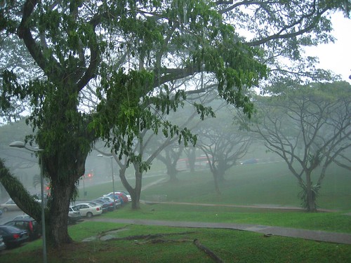
To be honest, in case you didn't know this, Singapore has undergone intensive flood management and modifications over the years. All these concrete canals that people complain about actually are the key to flood management in Singapore. From regular floodings from heavy December monsoons and flash floods, to a relatively uneventful "hazard-free" island country. I grow up learning simplistically that Singapore is a great country for FDI because we are safe from any natural hazards. Over the years, we became complacent. I even started to really believe that we are sheltered from all hazards.

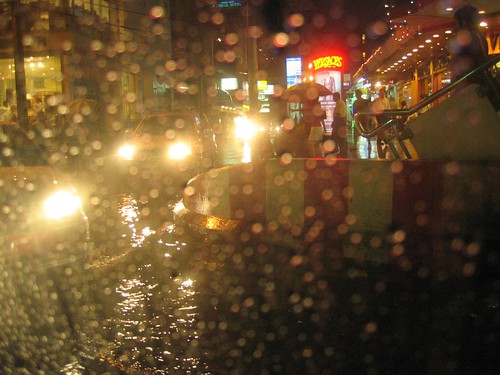
Then we started to hear rumours about Singapore being potentially vulnerable to tsunamis, earthquake aftershocks felt in parts of Singapore and then landslides and now we have cars being half submerged due to heavy rains!


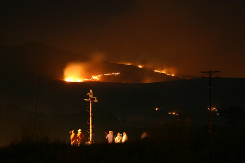
Most of these occurrences happen during this December-January period when Singapore is in the path of the northeast monsoon. The landslide in NUS Business School for example happened in January 2006 and earlier this year on 8 January 2006, I blogged about the extreme rain, landslides and comparative dry weather we had in 2005 that led to forest fires. So what is worse - floods or fires?

On 14 April 2006, I blogged about flash floods in Singapore and even then I noted how it is not from a lack of trying that we still continue to suffer from floods. Do not be mistaken. The Singapore government and various agencies have been working miracles over the years but it is time Singaporeans are more aware of the low-lying nature of our island. We are susceptible to flood. My mom recounted the days when my aunt lived downtown near the rochor, chinatown area where they were constantly plagued by annual floods. Back then, their beds were on stilts and things were never left on the floor. Floods were something people lived with.


At least we no longer flood like Bangkok but we used to!

But now? We are unused to floods and therefore suffer from being caught off guard.

Hey, even the best gets caught unaware. Look at New Orleans. That is the place of regular flooding but even the city was wiped out due to unknown highs. In all my natural hazards textbooks, it is always written about how people try to predict what the highest flood level would be and then still getting caught off guard. What is a 100 year flood? The rain measurement we had on Tuesday was apparently the 3rd highest in almost 75 years. Still people get caught off guard because it's been such a long time since the last high which was in 1978.

If we all start to build levees and protective walls along our water channels, think of how high we have to keep building and how ugly it would be when somewhere in the lull period, somebody looks at it and complain to the gahmen as to why we need such a wall when there is no flood. So they tear it down and the next year we get hit by a flood. No no no, protective walls and levees are not the answer.


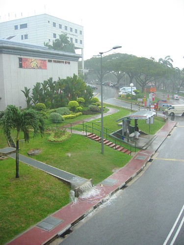
That is not just a massive longkang. It used to be a river but how much longer can it hold the water in?

So what is the answer? Perhaps the marina barrage?

It is written on the Marina Barrage website that one of the purpose of the barrage is for flood control.

"The Marina Barrage is also part of a comprehensive flood control scheme to alleviate flooding in the low-lying areas in the city, such as Boat Quay, Shenton Way, Geylang, Chinatown and Jalan Besar.

With the Barrage and other drainage projects concurrently being implemented, flood-prone areas will be reduced from the current 150 ha to 85 ha. A significant achievement considering that back in the 1970s, the flood-prone areas were about 3,200 ha."

How It Works

The barrage will separate the seawater from the freshwater and act as a tidal barrier to keep out the high tides.

Under normal conditions, the crest gates will remain in an upright position to separate the reservoir from the sea.

If it rains heavily during high tide, the crest gates remain upright and excess storm water is pumped out into the sea.

As such, with the Barrage in place, the pockets of low-lying areas in the city will no longer be prone to flooding.

Notice the low lying areas that were stated on the marine barrage website. These are the very same areas that the meteorological service sent a warning to yesterday:
i) Chinatown/ City area
Mosque Street, Pagoda Street, Temple Street, Trengganu Street, Upper Pickering Street between South Bridge Road and New Bridge Road, South Bridge Road, Upper Hokkien Street between South Bridge Road and New Bridge Road, Chulia Street beside UOB Plaza, Circular Road and McCallum Street/Boon Tat Link;

ii) Tanjong Katong area
Dakota Crescent, Meyer Place, Meyer Road, Dunman Road, Fort Road, Rose Lane and Stadium Road;

iii) Geylang area
Guillemard Road between Lor 26 to 32 Geylang, Lor 4 to Lor 22, Geylang, Lor 101 to 106, Changi Road and Langsat Road;

iv) Area off Jalan Besar between Weld Road and Kitchener Road;

v) Lorong Buangkok.
Police said that the flood at the junction of Admiralty Rd West and Woodlands Ave 10 has subsided.
Those areas that are mostly affected are usually the river delta, estuary areas, near a reservoir or large body of water or near the river. Of course, we think nothing of these waterways in our urban environment as over the years we have been writing them off as "drains" and "longkangs" instead of rivers with active hydrological processes. We begin to underestimate the powers of nature, rain, monsoon and most of all, the tide. But notice that there are also many other areas that are not covered under the Marina Barrage's coverage. In fact, in the April report on flash floods, "police said they received many calls about flooding in low-lying areas in Chai Chee, Bedok Reservoir and the PIE towards Changi". Even our airport will not be spared, surely being reclaimed, lowlying and near the coast. Previous flash floods have also inundated east coast and buried it under a large pile of sand from monsoon deposition. Of course immediate actions were taken to elevate these lowlying coastal areas. What more, all our storm drains and canals are connected to our reservoirs and as this current flood event showed us, the ones with pipes junctures leading to the reservoirs flood more easily! It's like being at the center of the traffic jam.


Friends, romans and countrymen, ultimately, the take home message is that:

WE FLOOD.

Indeed, and very regularly as well! So what do we do about it? Well the government is already doing their best but it helps that we are on our toes and are aware of our environment. First of all, know when the monsoon season is. Second of all, if you see your pond being submerged, salvage the fish before it gets washed away. Make flood precautions. Do not walk near gushing drains in the rain if you know that you might get swept away. Don't get swept away then blame it on the government for not building railings. (Yes, seriously this happened near my house a few years ago) Most of all, opt for green cover instead of paving all our ground cover in your schools and estates! Trees, plants and grasses does an amazing ecological service for us in terms of moderating flood events. It's natural engineering.

Of course, perhaps the most logical for Singapore's case is to, STOP LITTERING. It was reported on the news that the Thompson road flooding was partly due to the cluttering of the drains with litter and even a fridge! This reminded me of a presentation by the waterways watch representative where they expressed the pains of seeing singaporeans litter our waterways! c'mon people, stop it. A fridge?!

CNA reported that "According to the Public Utilities Board, about 1,500kg of debris — including plants and cardboard boxes — have been cleared from drains in Olive Road, the area worst hit by the rains."

And again, even though the affected nursery at Thompson Road mentioned that flooding is a regular event in the area, this came unexpectedly. There have been so much research done in the past and even in the present about why people continue to live in flood plains but in Singapore, it's more a matter of our insensitivity towards our natural environment and its processes. Let's stop overestimating the engineering works, underestimating the powers of nature and our over reliance and complacency!


In this age of climate change and sea level rise, there is more need for consideration of such things as flooding. Imagine if the sea level is already risen and add to that a major rain event and flash floods. More areas will be affected! The landslide that occurred in NUS also happened during the monsoon season in January. What more, there is already landslides happening during yesterday's rain event. Add to that the concretization of all our ground cover, that makes the water runoff even more intensive and our slopes become more vulnerable to landslides. Our drain capacity is limited because it is afterall a fixed concrete container, unlike the natural abundance and flexibility of our soil. But even that is limited, much less our drains. When our drains overflow and our canals spill over, are you ready for it?

Updates
27 Dec 2006 - "Slope failure forces two Singaporean families to evacuate homes" [link]


Read full article here